Understand Copenhagen Harbor's traffic lights and signage

Copenhagen's recreational harbor has many users. Kayaks, rowing boats, canal cruises, motor boats, stand up paddle boards, harbor buses, sailing ships and rental boats bring life to the harbor every day. Being that many users of the harbor, we must take good care of each other and familiarize ourselves with the rules for proper behavior. It is important to understand Copenhagen Harbor's traffic lights and signage before you set sails - regardless of whether you are new on the water or an experienced skipper.
Where is it safe to sail in Copenhagen Harbor?
Traffic lights and road signs are the harbor's aids-to-navigation. They show where it is safe to sail, where you must pay attention and where you cannot sail. There are green, yellow, red and black water markings. The markings have different forms and thus different meanings. Below, we will teach you how to understand aids-to-navigation when you are on the water in Copenhagen Harbor. We will start by explaining some important maritime terms.
What is starboard and port?
To locate the shipping lane and by that where it is deep enough for you to sail, you need to look for side markings. There is a large difference in depth in Copenhagen Harbor. Along Islands Brygge there is, for example, a depth of seven meters. In contrast, along the main course of the harbor as well as in canals and side courses, it is generally only two to four meters deep. Therefore, as a user of the Port of Copenhagen, you must keep an eye on side markings.
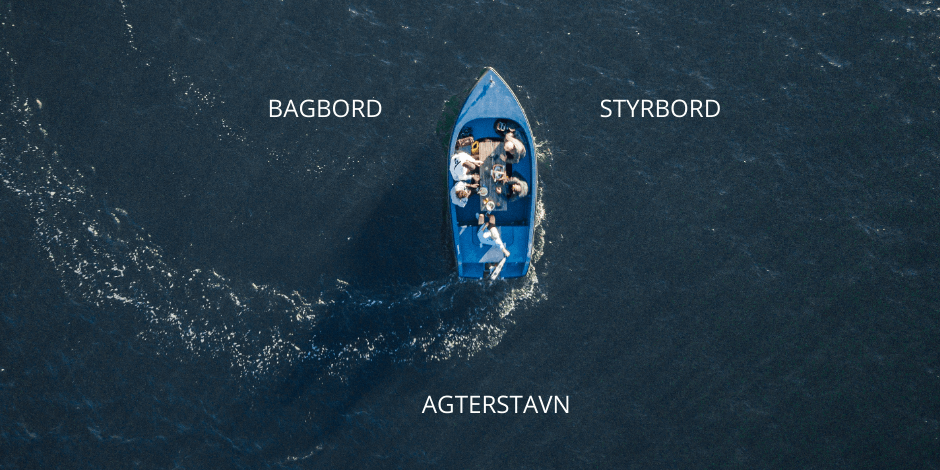
In order to understand the side markings, you need to know the difference between starboard and port. Port is the side of the ship that is to the left when looking forward towards the front of the ship in the normal sailing direction. Starboard is on the right side of the ship when looking forward towards the front of the ship. The rear part of the ship is called the stern.
Definition of the sailing direction
In Copenhagen Harbor, the sailing direction goes from Kronløbet in the north towards Slusen in the south. Kronløbet is the waters north of the sea fort Trekroner, which connects Copenhagen Harbor with Kongedybet in Øresund. When sailing in the shipping lane, the side markings (the green and red buoys) will indicate the starboard side and the port side in relation to the sailing direction from Kronløbet to Slusen. If you are sailing in the inbound direction (from Kronløbet to Slusen), you want the green buoys on the starboard side, and if you are sailing outbound, you have the green buoys on the port side.
The sailing direction is solely a convention that determines the marking of shipping lanes, and therefore has nothing to do with which direction you are sailing in a specific situation. It has been determined, and therefore it is something you just need to know. However, you must be aware that there are places in the harbor where you are only permitted to sail in one direction, which is, for example, in Frederiksholms Kanal from Den Sorte Diamant.
With starboard and port as well as the sailing direction and shipping line in place, we will move on to the side markings, the green and the red buoys. You are now one step closer to understanding Copenhagen Harbor's traffic lights and signage.
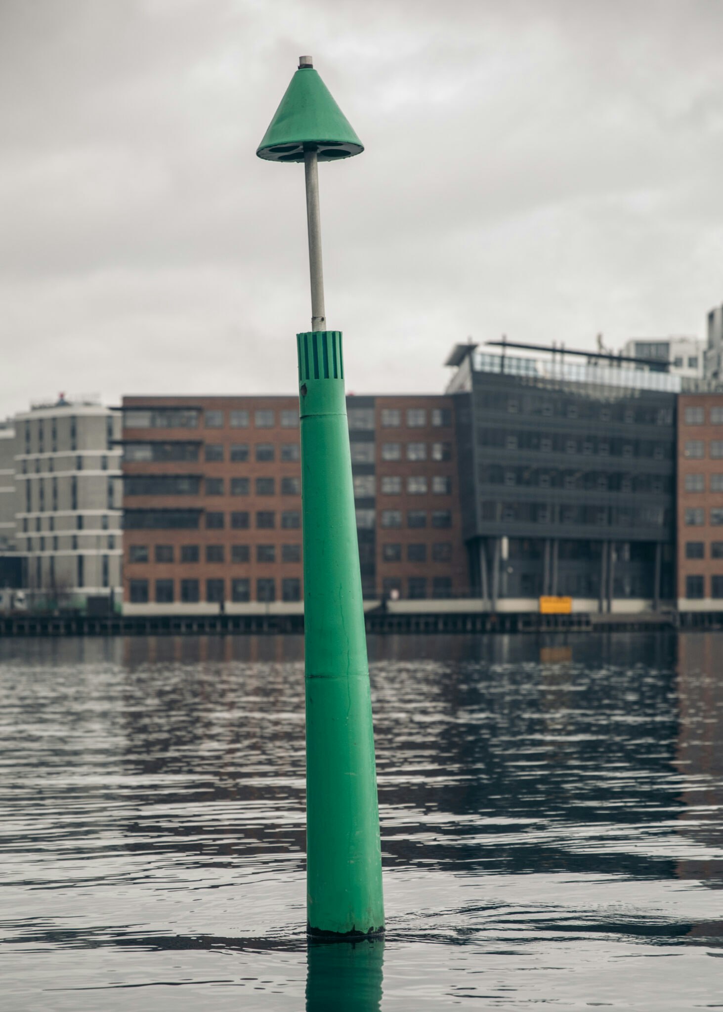
Understanding the port's traffic lights: Green buoys
The green side markings mark starboard when approaching in the sailing direction (from north to south in Copenhagen Harbour), while the red ones mark port. If you are sailing in the outbound direction (from south to north in the Port of Copenhagen), the green side markings will be on the port side and the red on the starboard side.
In addition to being green, they are also characterized by being triangular or cone-shaped with a green reflective band. If you sail in the shipping lane where there is enough depth, in the same direction as the sailing direction, you will have the green side markings to starboard. If you are sailing against the sailing direction, you will have the green side markings to port.
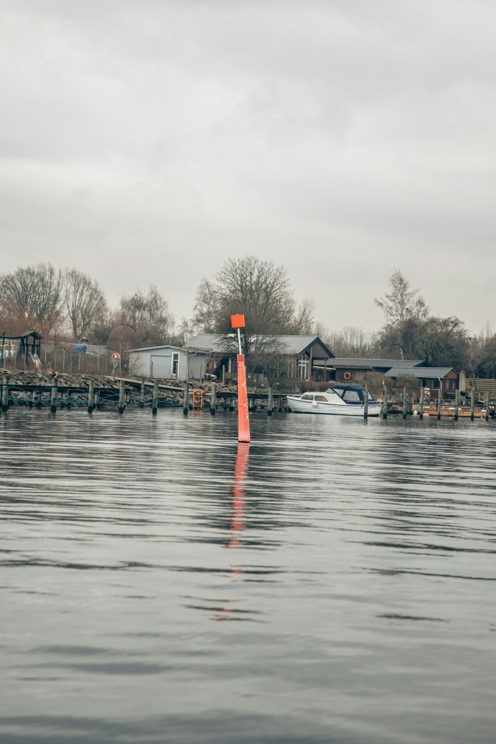
Understanding the port's traffic lights: Red buoys
The red side markings are characterized by having a square or cylinder shape. If you are sailing inbound in the sailing direction, you will have the red buoys on the port side. If you are in the outward direction, you will have the red buoys on the starboard side.
If you see a buoy that is both red and green, it means that the shipping lane is splitting. This is called a breakpoint marking. There is such a buoy north of Sluseholmen, where the channel divides into Sluseløbet and Teglværksløbet, respectively.
As such, if you are onboard a GoBoat, you don't have to worry about the depth of the shipping lane (apart from yellow buoys, which we'll get to in a bit). You should always keep to starboard and stay close to the sides of the runs. Here you will be of the least bother to larger boats and ships, such as The harbor buses. If you have to cross the harbor run, if you’re coming from the South and going through Frederiksholms Kanal for instance, be aware of other boats and ships so that you avoid a situation that could end in a collision.
What if two boats are sailing directly towards each other?
If two boats are sailing directly or almost directly towards each other, they must both turn to starboard to avoid collision. If the two boats are sailing on intersecting courses and there is danger of collision, the boat which has the other on its starboard side must move out of the way. If you sail with a GoBoat, you must always give way to the port's larger players, such as the harbor buses or the canal cruises.
In short, the red and green side markings indicate where the shipping lane is deep enough for sailing. You must keep the red cylindrical buoys on the port side when sailing inbound, and the green cone-shaped buoys on the starboard side. If you are sailing in an outbound direction, you must have the green buoys on the port side and the red ones on the starboard side. If you are sailing a smaller boat, such as a GoBoat, you can always keep to starboard and use the sides of the runs, where you are of the least bother to the larger boats in the harbor.
Understanding the port's traffic lights: Yellow buoys
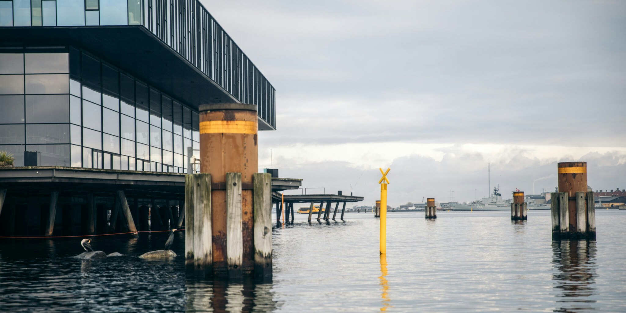
If you see yellow buoys with a cross at the top, you must pay extra attention. The buoys, which are called special markings, are used to indicate special objects or areas that must not be sailed across. The shape of the buoy follows the rules for sidemarking, which means that you must keep cylinder-shaped buoys on the port side when sailing inbound, and cone-shaped buoys on the starboard side.
Obstacles when sailing in Copenhagen Harbor
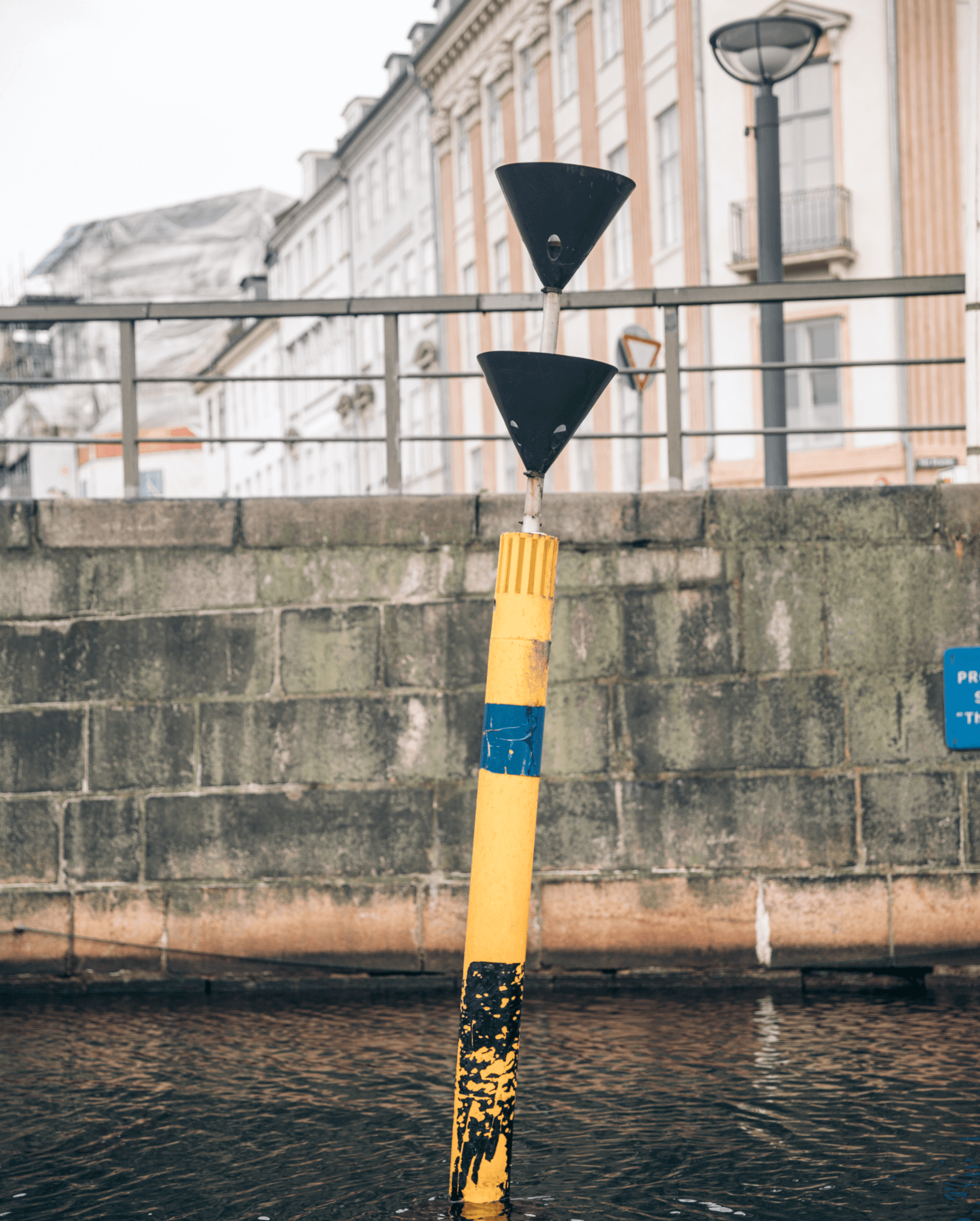
There may be possible obstacles along the way that you must pay particular attention to. Compass markings are used to mark these. A compass mark indicates an obstacle or possible danger. In addition, it indicates on which side the marking must be passed. The buoy can be located either north, east, south or west of the obstacle and can be recognized by the two black cones on top. The compass markings are placed in compass directions in relation to the obstacle, i.e. a north buoy at the north end, a south buoy at the south end of the obstacle, etc. It is therefore important that you know the direction towards the corners of the world. Nordhavn is to the north and Sydhavn to the south. An example of a compass marking is at the low water area near Fisketorvet.
Signage in Copenhagen Harbor
In order to understand Copenhagen Harbor's traffic lights and signage, in addition to knowing the meanings of the various buoys, you must also pay attention to the harbor's signs. There are only a few signs in the harbor so it is easy to remember them. They talk about rules for behavior on the water.
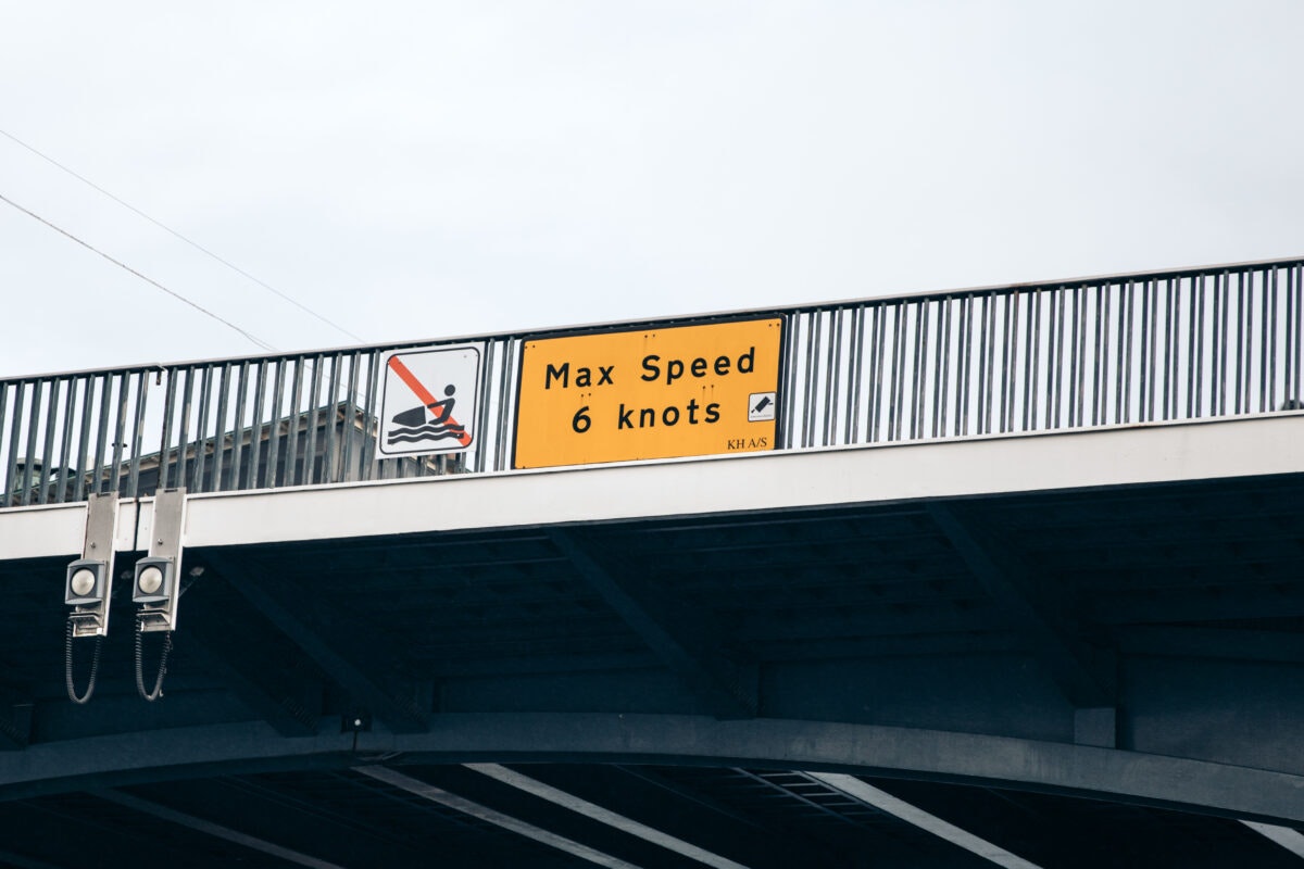
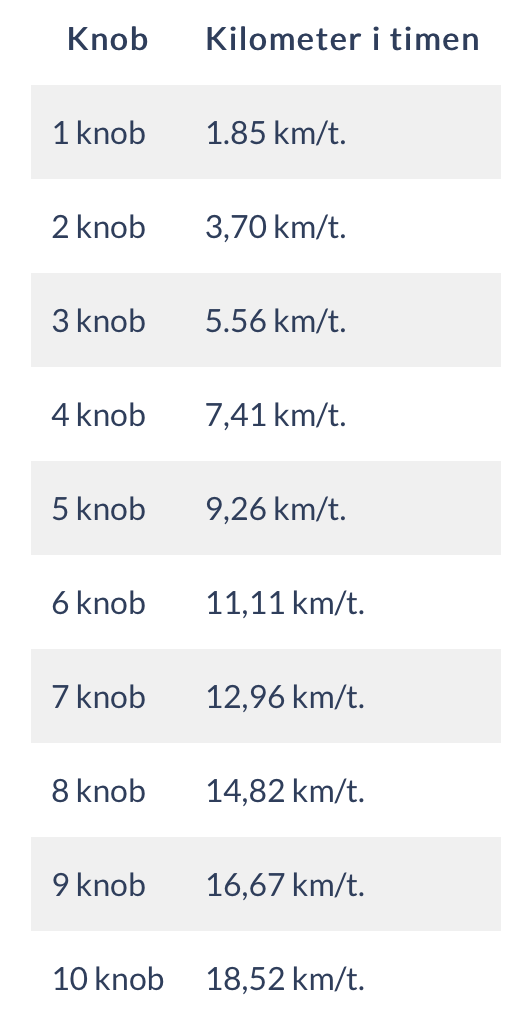
Speed signs: How many knots are you allowed to sail in Copenhagen Harbor?
Yachts can sail a maximum of 6 knots in the main run, which runs from Kronløbet in the north to the Slusen in the south, and 4 knots in the canals. However, you may come across signs with the text "Show consideration max 3 knots", in smaller canals close to residential areas. We are many users of the harbor, and we must therefore show consideration towards each other - including those who live close to the harbor.
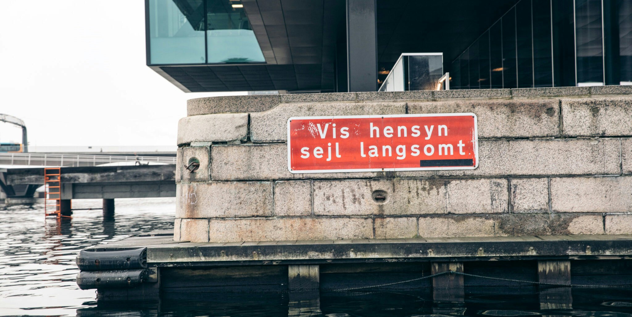
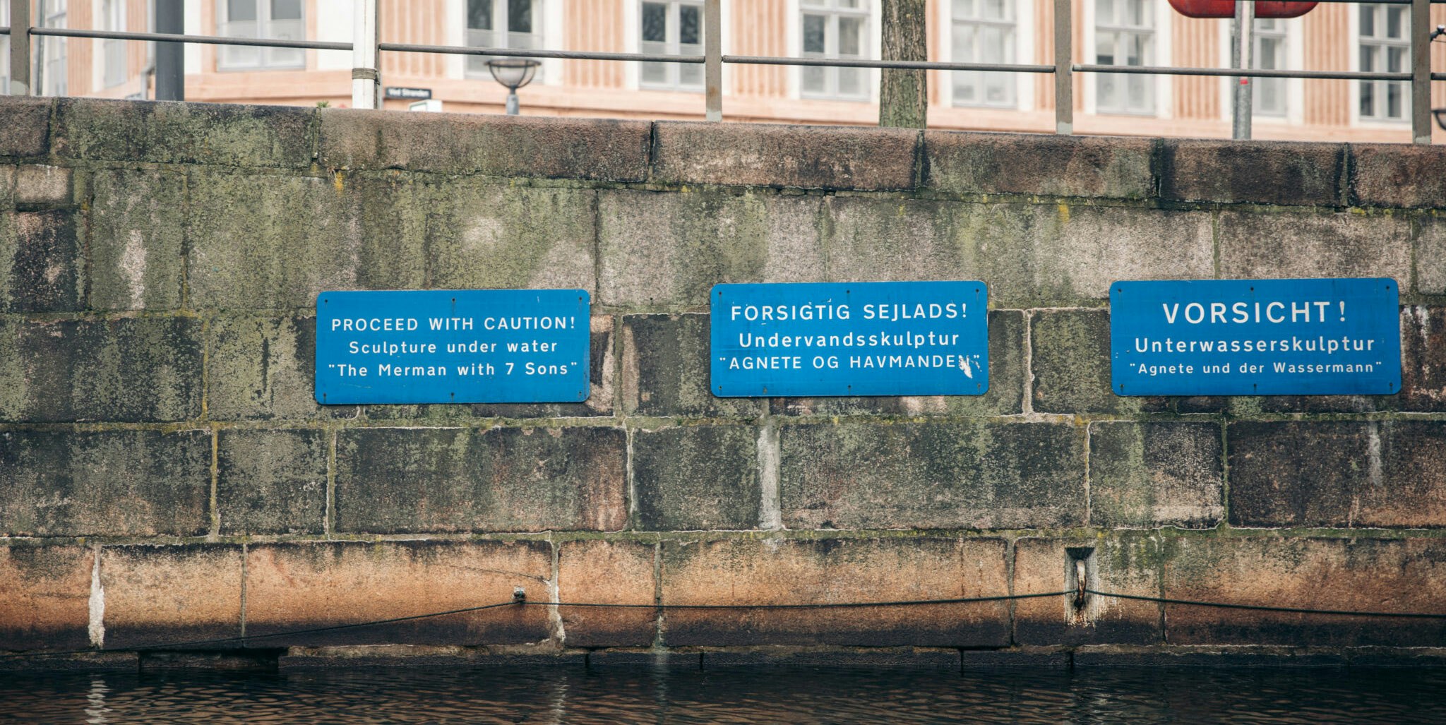
In addition, you may come across a sign with "Caution while sailing", which indicates that you must pay extra attention. In Slotsholmen Canal at Højbro, where the underwater sculpture "Agnete and the Seaman" from 1992 is located, you will come across a sign about careful sailing, for example.
Sailing prohibited signs
In addition to speed signs, there are yellow signs which mark the military area Marinestation Holmen, which is located off Nyholm. Sailing is prohibited here. Unauthorized ships and other vessels need permission from the military authorities to enter the area. If you sail in there without a permit, you can be fined. If you have rented a boat, it is the person renting the boat who must pay the fine. Additionally, note that boat rental companies have several areas where their boats are not allowed to sail for various reasons. For GoBoats, you can see on our map where you are not allowed to sail. The card is available in all boats and online.

Mooring prohibited signage
In addition to prohibited areas, there are also rules about where you can moor. It is forbidden to moor in several places in the harbor, and this is indicated by a "no mooring" sign. Among other places, it is forbidden to moor at the bridge piers, i.e. the pillars that support the bridges.

Bathing areas in Copenhagen Harbor
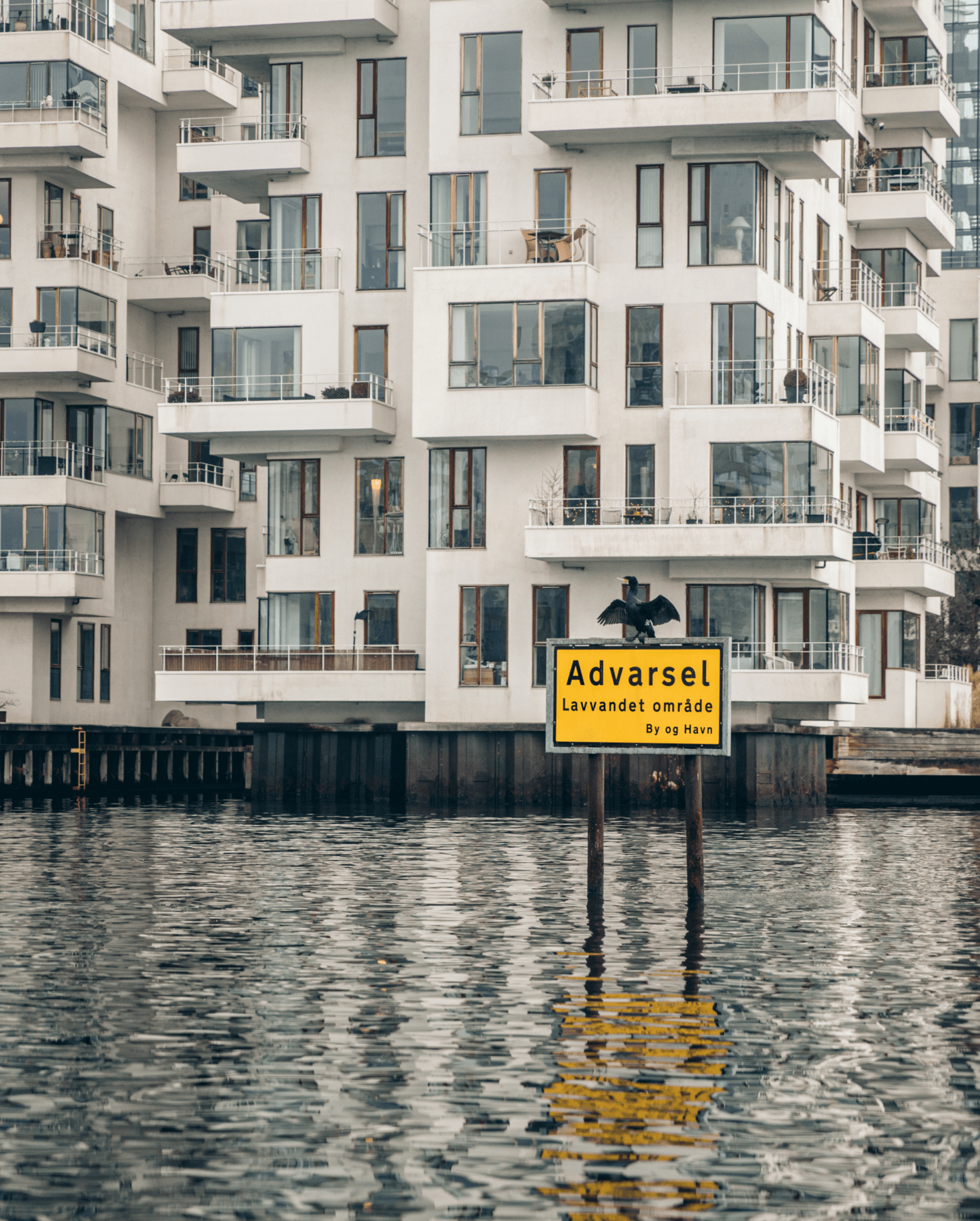
It can be difficult to see swimmers in the water if you arrive in the harbor by boat. Therefore, bathing is only permitted in areas where special bathing zones have been set up, where there is a sign with "Bathing allowed". The bathing zones are marked with yellow marker buoys connected to float tubes, lifelines along the quay and rescue ladders. It is therefore not permitted to jump into the water from your boat, kayak or stand up paddle board, as long as you are not in a bathing zone.
Bathing areas and harbor baths
There are six swimming areas and three harbor baths. The swimmings areas are at Sandkaj in Nordhavn, Halvandet on Refshaleøen, Søndre Refshalebassin, Islands Brygge, Kalvebod Bølge and Havnevigen. The harbor baths are located at Islands Brygge, Fisketorvet and Sluseholmen. The difference between harbor baths and swimming zones is that the harbor baths are surrounded by a physical facility, while the bathing zones are marked with buoys and float tubes. In addition, there are lifeguards present at the harbor baths during the day, which is not the case at the bathing areas.
Now you have learned more about and are able to understand Copenhagen Harbor's traffic lights and signage, and we wish you a pleasant sailing trip. You can read more about general rules in Copenhagen Harbor here.
Frequently asked questions
Hvad er en sejlrende?
Sejlrenden viser dig, hvor der er dybt nok til at du kan sejle. Grønne og røde sideafmærkninger indikerer hvor sejlrenden er.
Hvad er styrbord og bagbord?
Styrbord er i skibets højre side, når man ser fremad mod skibets forende. Bagbord er den side af skibet, der er til venstre, når man ser fremad mod skibets forende. Skibets bagerste del kaldes desuden agterstavn.
Hvilken vej går sejlretningen i inderhavnskanalen i Københavns Havn?
Sejlretningen er udelukkende en konvention, der fastlægger afmærkningen af sejlrender, og har derfor intet at gøre med i hvilken retning, du sejler i en konkret situation. I Københavns Havn går sejlretningen fra Kronløbet i nord mod Slusen i syd. Når man sejler i sejlrenden, vil sideafmærkningerne indikere styrbords- og bagbordsside i forhold til sejlretningen fra Kronløbet til Slusen.
Er der ensrettet i Københavns Havn?
Der steder i havnen, hvor der er ensrettet fx i Frederiksholms Kanal fra Den Sorte Diamant.
Hvad er forskellen på de røde og grønne sideafmærkninger/bøjer?
De røde og grønne sideafmærkninger/bøjer, viser dig sejlrenden, hvor der er dybt nok til, at du kan sejle i Københavns Havn. Du skal holde de røde bøjer om bagbord, når du sejler i indgående retning (fra nord til syd), og de grønne bøjer om styrbord. Sejler du en mindre båd, som fx. en GoBoat, kan du med fordel altid holde mod styrbord og benytte siderne af løbene, hvor du er mindst til gene for de større både i havnen.
Hvad betyder de gule bøjer?
Hvis du ser gule bøjer med kryds i toppen, skal du være ekstra opmærksom. Bøjerne, som kaldes specialafmærkninger, benyttes til at angive specielle genstande eller områder, som man ikke skal sejle ind over i Københavns Havn.
Hvor mange knob må man sejle i Københavns Havn?
Lystbåde må højst sejle 6 knob i hovedløbet som går fra Kronløbet i nord til Slusen i syd, og 4 knob i kanalerne. Dog kan du støde på skilte med teksten “Vis hensyn max 3 knob”, i mindre kanaler tæt på beboelse.
Er det tilladt at fortøje overalt i Københavns Havn?
Det er forbudt at fortøje flere steder i havnen langs kajen, og det indikeres med et “fortøjning forbudt” skilt. Det er også forbudt at fortøje ved bropillerne, dvs. søjlerne som holder broerne.